About the Project
An interactive map for exploring the historical Jewish community of Homestead, Pennsylvania
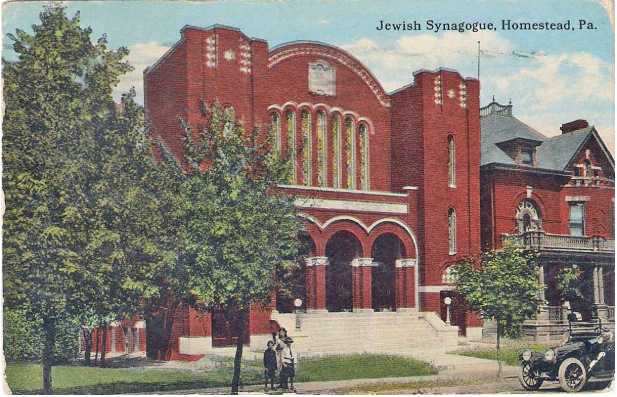
Homestead, Pennsylvania, located across the Monongahela River from Pittsburgh, is best known for its steel-making heritage. For a century, the riverfront was dominated by steel mills. After the collapse of the steel industry, the mills were replaced with big-box stores, and the area became a popular shopping destination. But before the steel mills and retail, the Homestead riverfront was a residential area with a thriving Jewish community.
This interactive map shows the Jewish community of Homestead from 1890-1945, as recorded in the city directories. Scroll through the time slider to examine the changing patterns of Jewish settlement, and then click a record to get more information about the people who lived there in that year.
- Search for a person by name or search for a current or historic address
- Symbolize the people by birth country, immmigration year, or synagogue membership
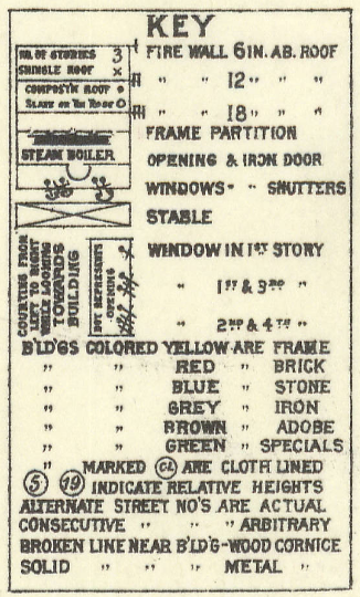
- See the Sanborn map legend and common abbreviations
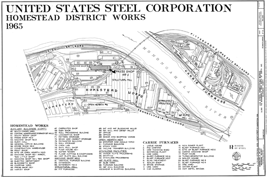
- See the 1944 and 1965 Homestead Steel Works site plan legends
Genealogical data provided by Tammy Hepps. For more information, visit Homestead Hebrews.
Map developed by Lauren Winkler.
Questions or Comments? Contact Us
Record Search
Search for a person by name.
Matching Records
*Head of household
Name (Record Year)
Display by Attribute
Show the households according to birth country, immigration year, or synagogue membership at the Homestead Hebrew Congregation
In households with multiple people, records are displayed based on the head of household.
Sanborn Map Legend
- D - Dwelling
- F - Flat
- S - Store
- B. & S. - Boots and shoes
- Clo. - Clothing
- D.G. - Dry goods
- Gro. - Grocery
- Off. - Office
- Sal. - Saloon
- Vac. - Vacant
- W. Ho. - Warehouse
- All Abbreviations
Homestead Steel Works Legends
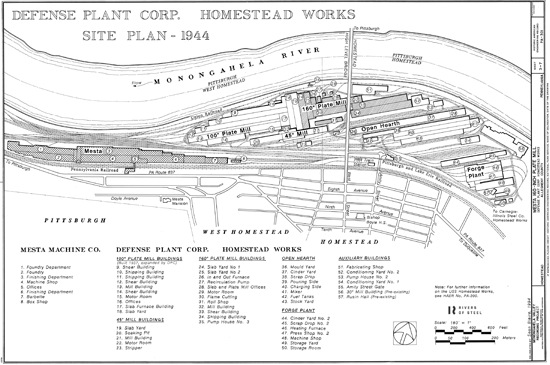
- Foundry Department
- Foundry
- Finishing Department
- Machine Shop
- Offices
- Finishing Department
- Barbette
- Box Shop
- Shear Building
- Shipping Building
- Shipping Building
- Shear Building
- Mill Building
- Shear Building
- Motor Room
- Offices
- Slab Furnace Building
- Slab Yard
- Slab Yard
- Soaking Pit
- Mill Building
- Motor Room
- Stripper
- Slab Yard No. 1
- Slab Yard No. 2
- In and Out Furnace
- Recirculation Pump
- Slab and Plate Mill Offices
- Motor Room
- Flame Cutting
- Roll Shop
- Mill Building
- Shear Building
- Shipping Building
- Pump House No. 3
- Mould Yard
- Cinder Yard
- Scrap Drop
- Pouring Side
- Charging Side
- Mixer
- Fuel Tanks
- Stock Yard
- Cinder Yard No. 2
- Scrap Drop No. 2
- Heating Furnace
- Press Shop No. 2
- Machine Shop
- Storage Yard
- Storage Room
- Fabricating Shop
- Conditioning Yard No. 2
- Pump House No. 2
- Conditioning Yard No. 1
- Amity Street Gate
- 30" Mill Building (Pre-existing)
- Rusin Hall (Pre-existing)
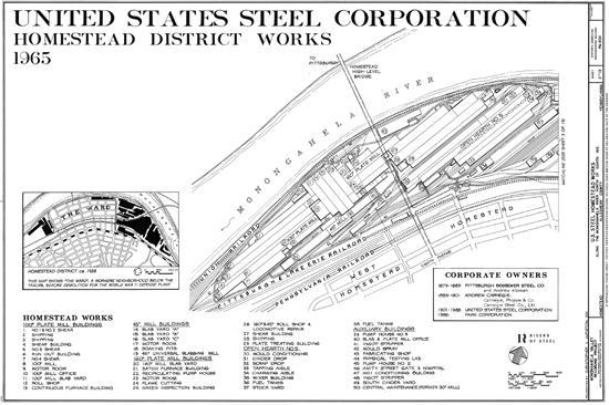
- No. 1 & No. 2 Shear
- Shipping
- Shipping
- Shear Building
- No. 3 Shear
- Run Out Building
- No. 4 Shear
- 100" Mill
- Motor Room
- 100" Mill Office
- 100" Mill Slab Yard
- Roll Shop
- Continuous Furnace Building
- Slab Yard "A"
- Slab Yard "B"
- Slab Yard "C"
- Motor Room
- Soaking Pits
- 45" Universal Slabbing Mill
- 160" Mill Slab Yard
- Batch Furnace Buildlng
- Recirculating Pump House
- Motor Room
- Flame Cutting
- Green Inspection Building
- 160" & 45" Roll Shop & Locomotive Repair
- Shear Building
- Shipping
- Plate Treating Building
- Mould Conditioning
- Cinder Drop
- Scrap Drop
- Tapping Aisle
- Charging Aisle
- Mixer Building
- Fuel Tanks
- Stock Yard
- Fuel Tanks
- Pump House No. 3
- Slab & Plate Mill Office
- Ingot Stripper
- Mould Spray
- Fabricating Shop
- Physical Testing Lab
- Pump House No. 2
- Amity Street Gate & Hospital
- No. 1 Conditioning Building
- Ingot Stripper
- South Cinder Yard
- Central Maintenance (Former 30" Mill)
- South Scrap Drop
- Press Shop No. 2
- Machine Shop No. 3
- Rusin Hall
- General Office Building
- Store Room No. 2
- Construction Warehouse
- Paint Shop
- Site Of Open Hearth No. 3
- Machine Shop No. 1 Annex, "Big Little Shop"
- Machine Shop No. 1, "Big Shop"
- Electric Department
- Blacksmith Shop
- Chipping Yard
- Press Shop No. 1
- Harvey Shop
- Carpenter Shop
- Sign Shop
- Roll Processing Building
- Locomotive Shop
- Pattern Storage
- Brick And Cement Storage
- Paymaster Buildlng
- Roll Storage
- Chem Lab
- Main Roll Shop
- Pump House No. 1
- Water Tower
- Flame Cutting & Conditioning
- 140" Plate Mill Building
- Vertical Furnace Building
- Extension
- Extension No. 2
- Pit Furnaces
- 54" and 44" Blooming Mills
- 52" Mill and 28"/32" Mills
- Office
- Office
- Shear And Shipping Yards
- Stripper And Mould Yard
- Furnace Building
- Stock Yard
- Incline Transfer Building
- Armor Plate Processing
- Shipping
- Stainless Processing
- Slab Yard
- Furnace Building
- 48" Mill Building
- Shear & Shipping Building
- Ladle House
- Pig Casting
- Ore Thawing Shed
- Sintering Plan
- Ore Yard
- Blast Furnace No. 6
- Blast Furnace No. 7
- Slag Treatment
- Boiler Shop
- Spare Storage
- Ore Yard
- Car Dumper
- No. 3 Power Plant
- Blast Furnace No. 1
- Site of Blast Furnace No. 2
- Carrie Machine Shop
- Pump House
- Turbo-Generator Buildlng
- Boiler House
- Blast Furnace No. 3
- Blast Furnace No. 4
- Ore Yard
- Water Plant
- Hot Metal Bridge
