Web Cartography
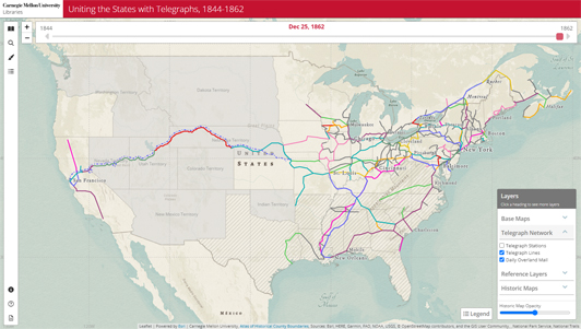
Uniting the States with Telegraphs, 1844-1862
Collaboration with Carnegie Mellon University Professor Edmund Russell to create the first digital map of a telegraph system
View the
Site
View a
Demo
View the Press Release
View our NACIS
2023 Presentation
Squirrel Hill Driving Tour
Experience Squirrel Hill's history, geography and notable sights in this driving tour around the neighborhood from the Squirrel Hill Historical Society.
Homestead Hebrew Maps
An interactive map of the historic Jewish community
of Homestead,
Pennsylvania
J.N. 'Ding' Darling
National Wildlife Refuge Visitor Map
A responsive map of America's birding hotspot in Sanibel, Florida
Nitrates and Cancer in Wisconsin
A spatial analysis of well nitrates and
cancer occurrences in
Wisconsin
Evolution of Pittsburgh's River Bridges
Interactive companion to Pittsburgh's Bridges (Images of America)
Lighting Energy Sources in Kenya
Electric vs. traditional lighting across Kenyan counties
Vacant Housing in Kentucky
Various types of vacant housing (rentals, houses for sale, seasonal properties, etc.) in Kentucky, as obtained from the 2010 U.S. Census
Heritage at Risk: The Loss of Historic Metal Truss Bridges in Pennsylvania
Documenting lost and at risk metal truss bridges in Pennsylvania
US Cancer Mortality Rates
CARTO web map showing the average cancer mortality rate from 2008-2012 in each US county, per 100,000 people.
Print Cartography

Map for The Adventures of Blas Garnier in Hispaniola
Map for The Adventures of Blas Garnier in Hispaniola by Madelyn Colon
Pittsburgh's Bridges
Companion poster to Pittsburgh's Bridges (Images of America)
Maps for Engineering Pittsburgh: A History of Roads, Rails, Canals, Bridges & More
Four maps for Engineering Pittsburgh: A History of Roads, Rails, Canals, Bridges & More.
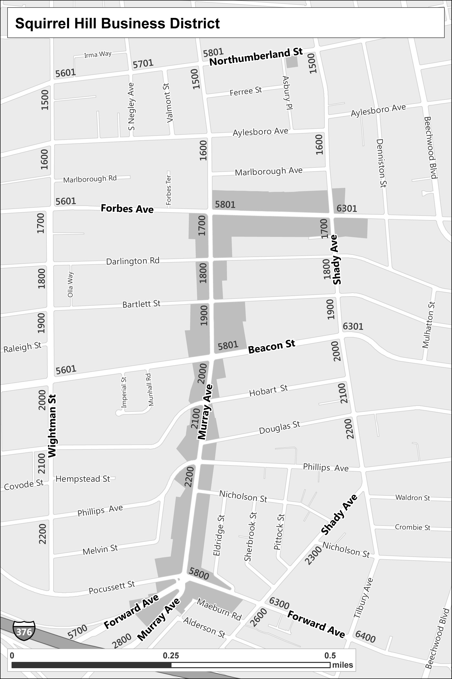
Maps for Squirrel Hill: A Neighborhood History
Three maps for Squirrel Hill: A Neighborhood History.
The Appalachian Trail
The Appalachian Trail on a georeferenced copy of the 1957 Landforms of the United States map by Erwin Raisz.
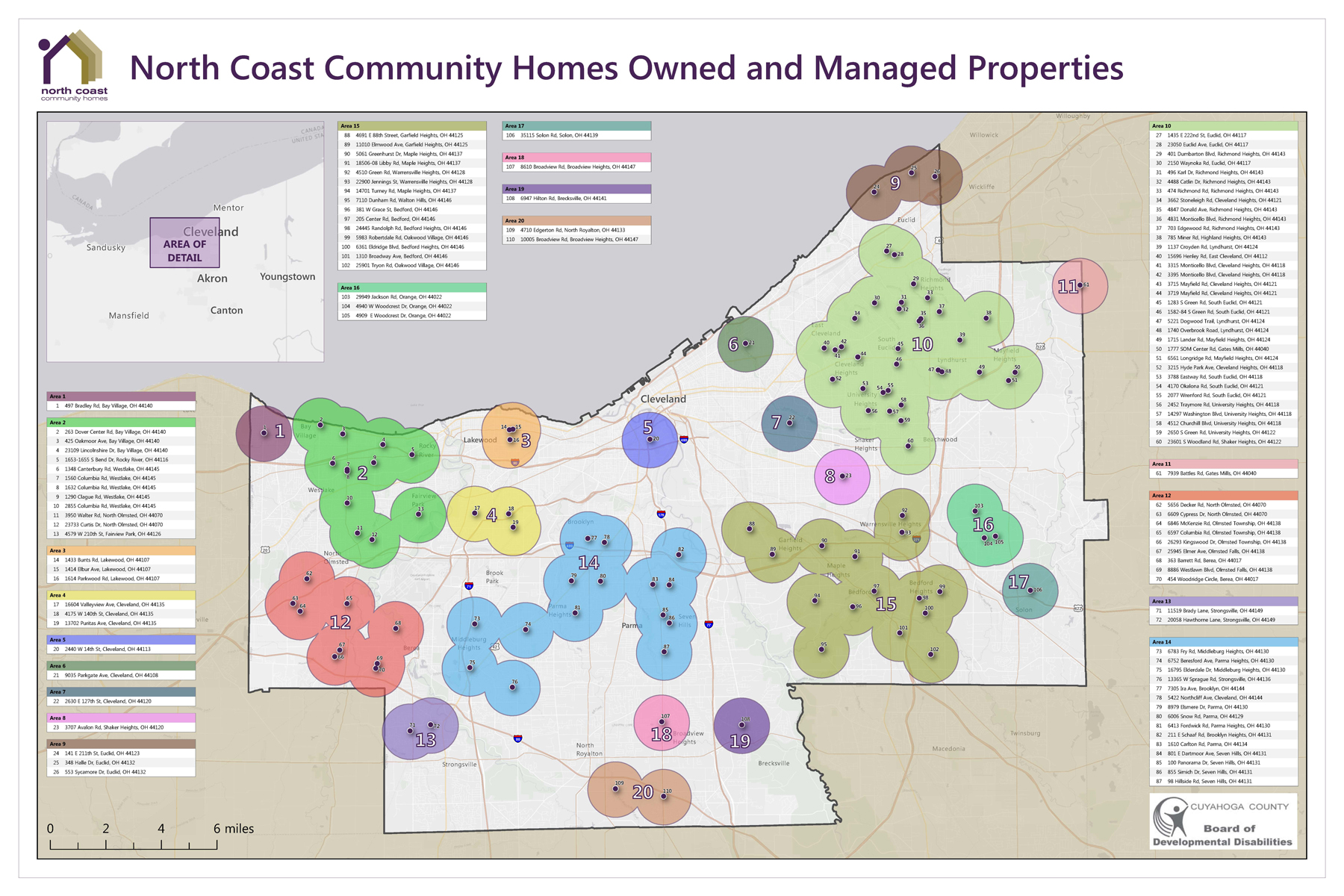
North Coast Community Homes Owned and Managed Properties
Properties owned and managed by the Cuyahoga County, Ohio non-profit
Uniting the States with Telegraphs,
1844-1862
The first interactive map of a telegraph network
Edmund Russell, Carnegie Mellon University, and various primary sources, scholarly research, and reference sources. See the Data Sources tab in the site.
Development languages:Leaflet, Esri Leaflet, Scrollama, jQuery, jQuery UI, JavaScript, HTML, CSS
Software used:GitHub, Visual Studio Code, XAMPP, ArcGIS Pro, ArcGIS Online, ArcGIS Vector Tile Style Editor
Completed May 2023. Updates ongoing.
This interactive map, a collaboration with Edmund Russell, David M. Roderick Professor of Technology and Social Change, and Professor of History, at Carnegie Mellon University, shows the development of the North American telegraph network, from the first line between Baltimore and Washington, DC in 1844 to the transcontinental network of 1862. Users can scroll down in the sidebar to learn about the phases of telegraph development and scroll through the time slider to watch the network grow. Users can also click any telegraph line or station to get its company and opening date or search for any city to see its telegraph stations. Reference layers including Native American traditional land ownership, cessions, and reservations, changing state and territorial boundaries, elevation, precipitation, and rivers help put the telegraph system in its political, social, and environmental contexts.
The data is presented on a historic basemap, showing the 100 most populated cities in the U.S. in each decade from 1840-1860, along with major cities in Canada and smaller towns that were important in the telegraph network. This allows the telegraph network to be shown in its time, without the anachronism of cities and roads that did not yet exist.
The site was developed in Leaflet, Esri Leaflet, and Scrollama, with data stored in ArcGIS Online.
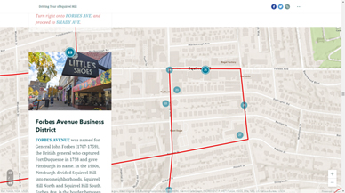
Squirrel Hill Driving Tour
Squirrel Hill, Pittsburgh, Pennsylvania

Squirrel Hill Historical Society, Allegheny County GIS Open Data
Software used:ArcGIS Pro, ArcGIS Online, ArcGIS Story Maps
Completed October 2020, last updated February 2021
Experience Squirrel Hill's history, geography, and notable sights in this driving tour around the neighborhood. This ArcGIS Story Map is a digitized version of the driving tour written by Helen Wilson, Squirrel Hill Historical Society Vice President, revised in October 2020. Users can scroll through the tour to virtually drive through the 55 stops. Photos, information, and driving directions are provided for each stop.
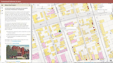
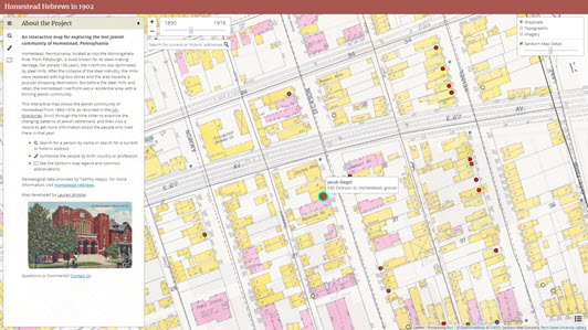
Homestead Hebrew Maps
An Interactive Map for Exploring the Lost Jewish Community
of Homestead, Pennsylvania
Homestead Hebrews, Don's List, Penn State University Library, Allegheny County GIS Open Data
Development languages:Leaflet, Esri Leaflet, jQuery, jQuery UI, JavaScript, HTML, CSS
Software used:GitHub, Brackets, ArcGIS Desktop, ArcGIS Online
Version 1 completed November 2018. Updates ongoing.
This interactive map shows the Jewish community of Homestead, Pennsylvania from 1890-1945, as recorded in the city directories. Users can scroll through the time slider to examine the changing patterns of Jewish settlement, and then click a record to get more information about the people who lived there in that year. Users can also search for a person by name, search for a current or historic address, symbolize residents by birth country, immigration date, or membership at the Homestead Hebrew Congregation, and examine historic Sanborn maps of the community.
The historic maps in the background are Sanborn fire insurance maps from all available years between 1890 and 1945. The Sanborns were previously only available as paper maps and digital image files. By georeferencing them, stitching them together, and publishing them as hosted tile layers in ArcGIS Online, I was able to bring them to life in this site.
City directory records and genealogical data were provided by Tammy Hepps. For more information, visit Homestead Hebrews. Based on existing street centerlines and the georeferenced Sanborn maps, I used ArcGIS to develop historic street centerlines and address ranges for each year with Sanborn maps, and then geocoded the directory records against those street centerlines and manually updated them to locate all residents at their residential address listed in the directory.
The site was developed in Leaflet, with data stored in GeoJSON files. It is based on Boilerplate HTML and Bootstrap, with user interface elements from jQuery and various Leaflet plugins.
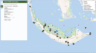
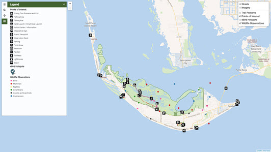
J.N. 'Ding' Darling National Wildlife
Refuge Visitor Map
Sanibel, Florida
U.S. Fish and Wildlife Service
Development languages:Leaflet, CARTO SQL API, based on PostgreSQL and PostGIS, jQuery, jQuery UI, JavaScript, HTML, CSS
Software used:CARTO, GitHub, Brackets, ArcGIS Desktop, ArcGIS Online
Completed November 2018
This site is an interactive visitor map of the J.N. "Ding" Darling National Wildlife Refuge in Sanibel, Florida. The map is focused on the themes of general tourism and ecotourism and has a mobile-friendly layout that is compatible with any desktop and mobile devices.
Users can click any feature to get more information, filter the points of interest by category or location, view wildlife observations submitted by other visitors, and (when connected to an active CARTO API Key and PHP server) submit their own sightings. Users within the park and the immediately surrounding area can also see their current location on the map, filter the points of interest to those within 1/2 mile of their current location, and (when connected to an active CARTO API Key and PHP server) submit wildlife observations at their current location.
The site was developed in Leaflet, using CARTO as the spatial database and PostgreSQL and PostGIS from the CARTO SQL API to query the database. It is based on Boilerplate HTML and Bootstrap, with user interface elements from jQuery and various Leaflet plugins.
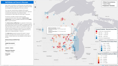
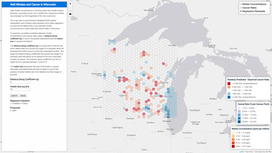
Spatial Analysis of Well Nitrates and
Cancer Occurrences
Wisconsin
Wisconsin Department of Natural Resources, provided by UW-Madison GIS Professional Programs
Development languages:Leaflet, Turf, Simple Statistics, jQuery, jQuery UI, JavaScript, HTML, CSS
Software used:GitHub, Brackets, ArcGIS Desktop
Completed October 2018
Research suggests that there may be a link between high concentrations of nitrates (and nitrites) in drinking water and cancer, but the magnitude of that relationship is not yet known. This map uses Inverse Distance Weighted (IDW) spatial interpolation and Ordinary Least Squares (OLS) linear regression to examine the relationship, if any, between nitrate concentrations in water wells and cancer rates in Wisconsin.
To examine a possible correlation between nitrate concentrations and cancer rates, users can select a distance decay coefficient (q) to use for the spatial interpolation and the hexbin size (in square kilometers). Based on this analysis, there is little correlation between nitrates in drinking water and cancer occurrences in Wisconsin over the 10 years included in the study.
The site was developed in Leaflet, using Turf for the geoprocessing, Simple Statistics to run the linear regression and generate class breaks for the resulting datasets, and the easyPrint Leaflet plugin to print the map to a PDF. It is based on Boilerplate HTML and Bootstrap, with user interface elements from jQuery and various Leaflet plugins.
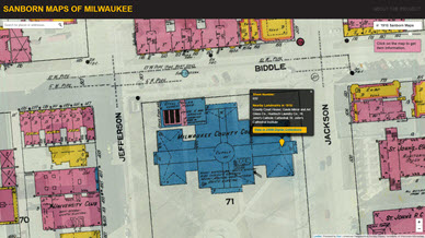
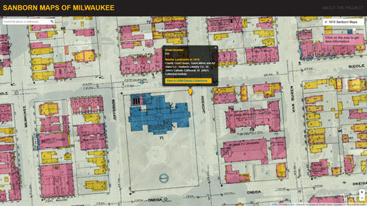
1910 Sanborn Maps of Milwaukee
Milwaukee, Wisconsin
1910 Sanborn Fire Insurance Maps and polygon boundaries of each map sheet, created by the American Geographical Society Library
Development languages:Leaflet, Esri Leaflet plugin, jQuery, JavaScript, HTML, CSS, Java
Software used:GitHub, Brackets, Eclipse IDE, pgAdmin, with PostgreSQL and PostGIS, ArcGIS Server
Completed April 2018
This is a mobile-friendly web map for librarians and the public to interact with the 1910 Sanborn Maps of Milwaukee, developed as a collaboration with Belle Lipton, of the American Geographical Society Library. We mosaicked and cached the historic maps, so that users can access them as a seamless, online dataset. Users can drag the opacity slider to compare the 1910 maps with the current city landscape and use the Esri Leaflet geocoder to search for a current address within the Milwaukee area. This map was developed using custom JavaScript based on the Leaflet and Esri Leaflet JavaScript APIs.
There is another version with user contribution functionality available here, which allows users to contribute information about historic buildings and landmarks. This version of the app also relies on a local PostgreSQL database with PostGIS, which communicates with the application via a Java servlet and database class. See a demo of the application here and see the database setup instructions to setup this database in pgAdmin.
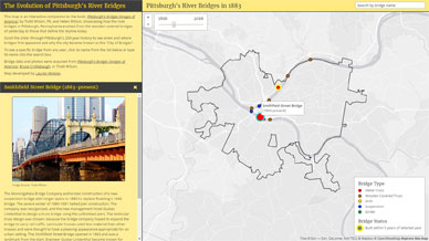
The Evolution of Pittsburgh's
River Bridges
Pittsburgh, Pennsylvania
Pittsburgh's Bridges (Images of America), City of Pittsburgh, Bruce Cridlebaugh
Development languages:Leaflet, Leaflet Omnivore plugin, Mapbox, jQuery, jQuery UI, JavaScript, HTML, CSS
Software used:GitHub, Brackets, Microsoft Excel
Completed June 2016
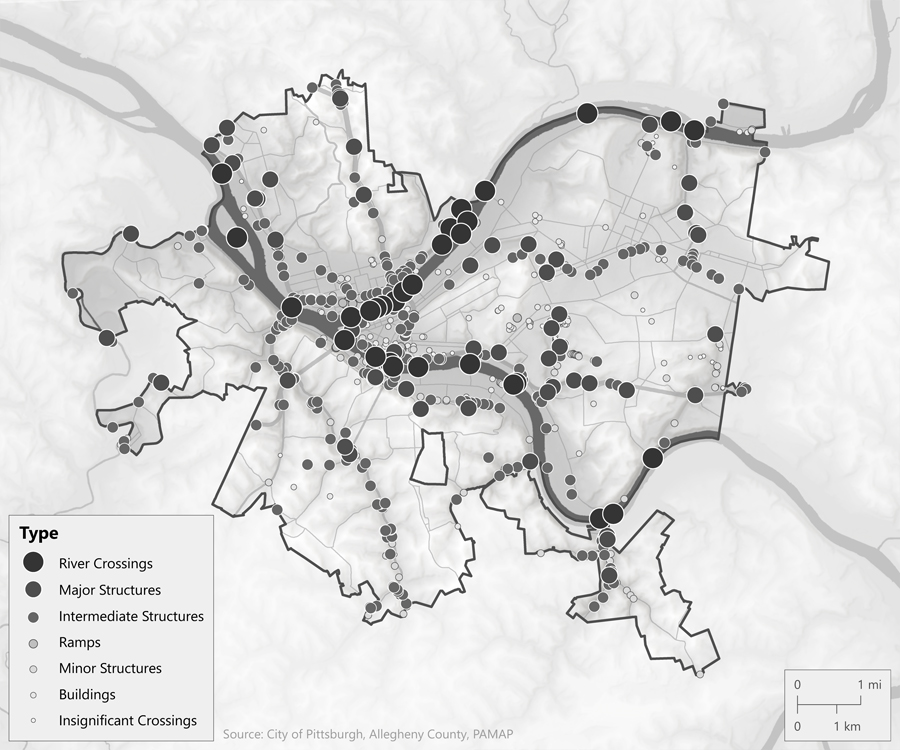
This map is an interactive companion to the book, Pittsburgh's Bridges (Images of America), by Todd Wilson, PE, and Helen Wilson, showcasing how the river bridges in Pittsburgh, Pennsylvania evolved from the wooden covered bridges of yesterday to those that define the skyline today. Users can scroll the slider through Pittsburgh's 200-year history to see when and where bridges first appeared and why the city became known as the "City of Bridges". The site also features a list and search for all of the city's river bridges - past and present.
This map was developed using custom JavaScript based on the Leaflet and Mapbox JavaScript APIs to import CSV data for the bridges as proportional circle markers, symbolize the markers based on the bridge type with a highlight for recently built bridges, create a custom year slider allowing users to see the bridges that existed in a specific year, and create a custom list and search box for users to select any bridge from any year.
This map utilized a mapping workflow based on Jesse James Garrett's elements of the user experience. Before developing the map, I identified the map's objectives and content and functional requirements and followed an example map and a mockup to guide the development process.
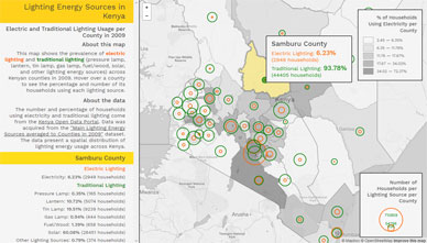
Lighting Energy Sources
Kenya
Kenya Open Data Portal, ArcGIS Online
Development languages:Leaflet, Leaflet Omnivore plugin, Mapbox, Simple Statistics, jQuery JavaScript, HTML, CSS,
Software used:GitHub, Brackets, QGIS, Microsoft Excel
Completed May 2016
This Leaflet and Mapbox web map shows the prevalence of electric lighting and traditional lighting (pressure lamp, lantern, tin lamp, gas lamp, fuel/wood, solar, and other lighting energy sources) across Kenyan counties in 2009. Electric and traditional lighting usage is represented as proportional symbols and the percentage of households using electricity per county is represented as a choropleth. Users can hover over a county to see the percentage and number of its households using each lighting source.
This map was developed using custom JavaScript based on the Leaflet and Mapbox JavaScript APIs to import GeoJSON data for electric and traditional lighting as proportional circle markers, dynamically join the electricity usage data to county boundaries to create a choropleth map, and create custom hovers and a detail panel showing the aggregated and individual lighting usage per county.
This map utilized a mapping workflow based on Jesse James Garrett's elements of the user experience. Before developing the map, I identified the map's objectives and content and functional requirements and followed an example map and a mockup to guide the development process.
Unemployment Rates: 2001-2013
Kentucky
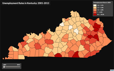
Unemployment Rates in Kentucky, Kentucky County Boundaries, both provided by University of Kentucky's New Maps Plus Graduate Certificate Program
Development languages:Leaflet, Papa Parse, Simple Statistics, jQuery, JavaScript, HTML, CSS
Software used:Completed April 2016
This Leaflet web map shows unemployment rates in Kentucky between 2001 and 2013.
This map was developed using custom JavaScript based on the Leaflet JavaScript API. The unemployment rate data is stored in a CSV file and joined to the county geometries using the Papa Parse JavaScript library. The unemployment rates per county are then represented as a choropleth map, using the ckmeans clustering method in the Simple Statistics library. Users can scroll the slider bar to see how unemployment rates have changed between 2001 and 2013.
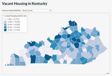
Vacant Housing
Kentucky
American Fact Finder: 2010 Census, SF1, Kentucky County Boundaries, provided by University of Kentucky's New Maps Plus Graduate Certificate Program
Development languages:Leaflet, Simple Statistics, jQuery, JavaScript, HTML, CSS
Software used:Completed April 2016
This Leaflet web map allows users to explore various types of vacant housing (rentals, houses for sale, seasonal properties, etc.) in Kentucky, as obtained from the 2010 U.S. Census. Users can select an attribute from the dropdown to explore the prevalence of that type of vacant housing across the state, click a county to view the vacancy rate for that type of housing, or hover over a county to view the total number of each type of vacant housing in that county.
This map was developed using custom JavaScript based on the Leaflet JavaScript API with an HTML dropdown. The housing vacancy rates are represented as a choropleth map, using the ckmeans clustering method in the Simple Statistics library.
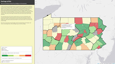
Heritage at Risk: The Loss of
Historic Metal Truss Bridges
Pennsylvania
2001 Pennsylvania Historic Bridge Survey (download Excel spreadsheet), PennDOT, Google Maps aerial imagery and Street View, Bridgehunter, HistoricBridges.org, and local knowledge
Development languages:CartoDB.js, JavaScript, HTML, CSS, Java
Software used:Completed June 2016
In 2001, an assessment showed that Pennsylvania had 333 historically significant metal truss bridges. Since then, 40% of those bridges intended to be preserved have been demolished. This CartoDB web map shows the state of historically significant metal truss bridges in Pennsylvania and identifies which counties and Pennsylvania Department of Transportation engineering districts have been most and least successful at their preservation.
Data is initially aggregated by couty. Users can click a county to see the percent of historically significant metal truss bridges remaining in that county. As they zoom in, individual bridges become visible, showing whether they are still standing or demolished. Users can click each bridge to get additional information.
This map was initially developed in CartoDB (now CARTO) by spatially joining the bridges and their statuses to county boundaries, calculating the county bridge retention rates, applying symbology using CartoCSS, and adding additional data, info windows, and explanatory text. Later, the map was customized using CartoDB.js.
Power Near and Far: Coal, Hydroelectric, and
Wind Power Plants
United States
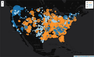
Electricity-generating power plants across the US, obtained from EIA form 923
Development languages:Leaflet, JavaScript, HTML, CSS
Software used:Completed March 2016
This Leaflet web map displays coal, hydroelectric, and wind power plants in the US. The size of the circle indicates the total electrical capacity of the power plant from all of its fuel sources, in megawatts.
Power plants from each fuel source are stored in layers, which users can turn on and off through the table of contents. Users can also click a point on the map to see only power plants within 500 km of that point and the total power they generate. After selecting an area of interest, users can click a specific power plant within the 500 km radius to see its name and electrical capacity.
This map was developed using custom JavaScript based on the Leaflet JavaScript API to import GeoJSON data as proportional circle markers, create a layer control, create a 500 km spotlight filter around a clicked point, and create popups of aggregated and individual electricity capacities.
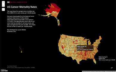
Cancer Mortality Rates
United States
National Cancer Institute's State Cancer Profiles, US Census Bureau TIGER Products
Software used:Completed November 2015
This CARTO web map shows the average cancer mortality rate from 2008-2012 in each US county, per 100,000 people.
Users can click a county to see its specific cancer mortality rate.
This map was developed in CartoDB (now CARTO) by joining a CSV file of cancer mortality rates to county boundaries, symbolizing the resulting data as a choropleth map using CartoCSS, and adding info windows and annotations.
Map for The Adventures of Blas Garnier in
Hispaniola by Madelyn Colon
Caribbean, 1800-1860
ArcGIS Living Atlas, Natural Earth, USGS, Madelyn Colon, and various online sources
Software used:Completed October 2024
This 12" x 9" map of the Caribbean was created for Madelyn Colon, for inclusion as a two-page spread in her forthcoming historical fiction book, The Adventures of Blas Garnier in Hispaniola. It shows the Caribbean as it existed from 1800-1860, with two insets showing the movement of slaves between the British, Dutch, French, and Danish Colonies and the route to freedom across the Mona Passage from slavery in Puerto Rico to freedom in Hispaniola.
The map was developed in ArcGIS Pro based on sketches provided by the author and historical research to identify the 19th century names and colonial powers controlling each island. Routes were created using the XY to Line tool, converted to Bezier curves, and labeled with custom annotation. The map also provided the opportunity to use a coastal halo effect. Credit to Geoffrey Wallace for connecting me with the author.
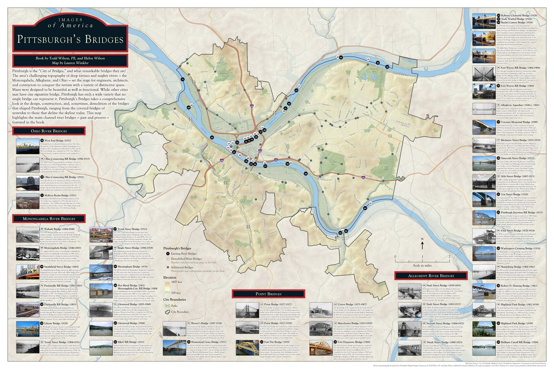
Pittsburgh's Bridges
Pittsburgh, Pennsylvania
Pittsburgh's Bridges (Images of America), City of Pittsburgh, Allegheny County, Pennsylvania Department of Conservation and Natural Resources
Software used:ArcGIS Desktop, Adobe Photoshop
Completed October 2015
This map is a companion poster to the book, Pittsburgh's Bridges (Images of America), by Todd Wilson, PE, and Helen Wilson. This poster highlights the river bridges -- past and present -- featured in the book. It was presented at the 2015 NACIS conference.
This map was developed in ArcGIS Desktop. Photos and information about each bridge were added in Photoshop.
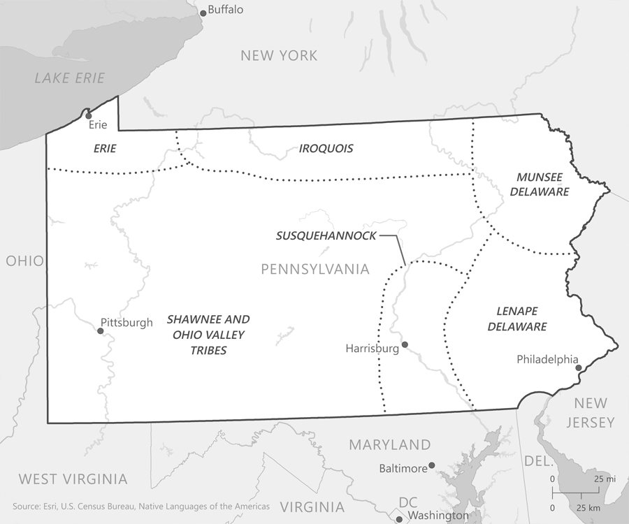
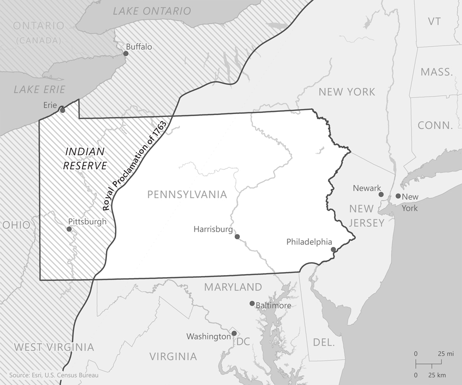
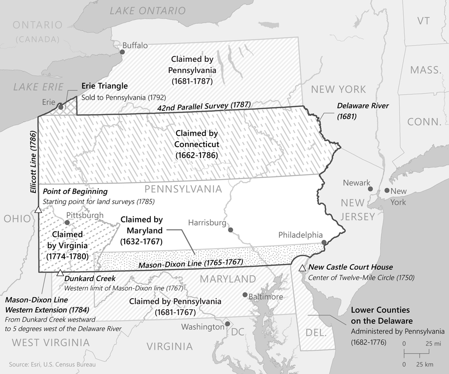
Maps for Engineering
Pittsburgh: A History of Roads, Rails, Canals, Bridges & More
Pennsylvania
Native Languages of the Americas, U.S. Census Bureau, Esri Data and Maps, Wikipedia
Software used:ArcGIS Desktop, Adobe Illustrator
Completed June 2018
Collaborating with the ASCE Pittsburgh Section 100th Anniversary Publication Committee, I developed four maps for their book, Engineering Pittsburgh: A History of Roads, Rails, Canals, Bridges & More. The maps accompany the chapters on bridges and Pennsylvania's borders. I collaborated with the authors and did additional research to create the necessary data.
The maps had to be in grayscale and no larger than 5" x 9" each. They were all developed in ArcGIS Desktop and customized in Illustrator.
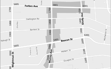
Maps for Squirrel Hill: A
Neighborhood History
Squirrel Hill, Pittsburgh, Pennsylvania

City of Pittsburgh, Allegheny County, Esri Data and Maps
Software used:ArcGIS Desktop, Adobe Illustrator
Completed September 2016
Collaborating with the Squirrel Hill Historical Society and editor Helen Wilson, I developed three maps for their book, Squirrel Hill: A Neighborhood History.
The maps had to be in grayscale and no larger than 5" x 9" each. They were all developed in ArcGIS Desktop and customized in Illustrator.
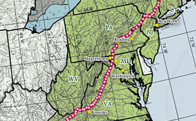
The Appalachian Trail
Landforms of the United States by Erwin Raisz (1957), Appalachian Trail Conservancy, US Census Bureau TIGER Products, Natural Earth
Software used:Completed November 2015
This print map displays the Appalachian Trail on a georeferenced copy of the 1957 Landforms of the United States map by Erwin Raisz.
This map was created in QGIS by georeferencing the Landforms of the United States map, using graticule intersections as the control points.
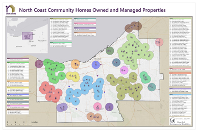
North Coast Community Homes Owned and
Managed Properties
Cuyahoga County, Ohio
North Coast Community Homes, Esri Data and Maps
Software used:ArcGIS Desktop, Adobe Illustrator
Completed September 2016
This map was designed for North Coast Community Homes, a non-profit organization in Cuyahoga County, OH that provides homes to people with disabilities. The map shows clusters of homes throughout the county within a one-mile radius of each other to encourage the tenants and staff to socialize with their neighbors. The homes were geocoded from a list of addresses, and then buffered by one mile. The overlapping buffers were dissolved to form neighborhoods. The map was designed to be 2' x 3'; a smaller version is included here.